• I want to thank all the members that have upgraded your accounts. I truly appreciate your support of the site monetarily. Supporting the site keeps this site up and running as a lot of work daily goes on behind the scenes. Click to Support Signs101 ...

near impossible vector job

The Vector Doctor

Chief Bezier Manipulator
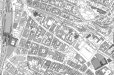
Someone sent me a file (see attachment). This is about 1/4 of the image that they wanted to have converted into vector. Well when you see it you'll understand why I turned it down. I could not post the entire image since it was too large.

So my question is, what kind of software would be used to create something like this? I assume there must be mapping software that aids this process. There aren't enough hours and free time in my day to do something like this by hand tracing.

Impossible no, but if anyone wants to tackle this I would be more than happy to give them your name.
 

Attachments

  • map.jpg
    map.jpg
    275 KB · Views: 343

signage

New Member
VD how big is the actual drawing? Graphtec make large scanners that are used for scanning this type of information into raster files.
 

Rick

Certified Enneadecagon Designer
Not that I would do it, but I have done my share of converting old hand drawn plans into vector drawings. I used Illustrator for it and did it all by hand and imported it into AutoCad. Not fun but it's what the boss needed done....mindless work that needs to be done in between fun stuff or you can go crazy.........that probably has 8-10 hours of work on it.
 

Flame

New Member
I would flat turn it down. I don't care if I could pull it off in 14 hours, I would fry my brain working on it. No thank you.
 

TC49010

New Member
Hey Eric!!!
I bet you really appreciate my simple little designs now huh?!!!:Big Laugh

I guess I am at a loss too as to why they would need it in vector.. that would be a easy print/cut to me.. theres no way I would attemp to weed that image!

Trixie
 

Pro Image

New Member
Eric

Whats the name of the park in the upper righ hand coner???:Big Laugh :Big Laugh :Big Laugh

Looks like F***n Park.................lol:Oops: :Big Laugh
 

The Vector Doctor

Chief Bezier Manipulator
Its a German city map from a German customer - Funckepark.

Apparently customer wants to use for Google sketchup program and to color houses individually. Thus the vector need.
 

The Vector Doctor

Chief Bezier Manipulator
TC49010 said:
Hey Eric!!!
I bet you really appreciate my simple little designs now huh?!!!:Big Laugh

I guess I am at a loss too as to why they would need it in vector.. that would be a easy print/cut to me.. theres no way I would attemp to weed that image!

Trixie

Yes a job like that would cause serious hand and brain discomfort.
 
I think I'm going to throw up after considering all that's involved with converting that to Vector... ((hand over mouth)) Gonna be sick!

Don't blame you for turning that down!
 

Pro Image

New Member
The Vector Doctor said:
Its a German city map from a German customer - Funckepark.

Apparently customer wants to use for Google sketchup program and to color houses individually. Thus the vector need.


DAMN German engineering............lol:Big Laugh
 

mark in tx

New Member
I know you pride yourself on fast turn-around, but you could charge whatever you want for that, and take 3 weeks to do it.
 

Bigdawg

Just Me
Would be a pure Illustrator redraw for me and there is no way I would do it to begin with. I'd tell them to overlay color layers in photshop if they want to colorize it.
 

Cadmn

New Member
I believe there is a web page that produces satelight mappings of housing sites
that might be worth looking into not sure how it might work but it is out there
 

OldPaint

New Member
i would tell them to have it printed as a bitmap and then....pay someone to color in the places they want colored......makes sence to me......
 

ENTDesign

New Member
If that is from a municipal (sp?) map, then the engineering/architect firm who produced this probably used a CAD program and perhaps can export it as a dfx file which could then be imported into Illustrator. They should ask the city government to see if this is so, and if they can get a copy of the file. They might have to pay for it.
 

geedub

New Member
ENTDesign said what I was about to say. There will be a company who originally drew this neighborhood/area and saved it as a .dwg or other cad format. If you can get ahold of them and ask them for the .dwg then you can use one of a number of programs to transform it into a .pdf and open it in illustrator. I use acme cad convertor. That will be your best way of getting vectors imo, other than that I'd have to pass on vectorizing that, because they're just going to come back with more and if they were to go to the engineering firm who made the original blueplan, they would save a LOT of money and your time....
 
Top